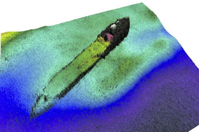
Detailed imaging of a massive steam ship, which sank off the Clare coast 125 years ago, have been revealed as part of the most detailed underwater survey ever undertaken in Ireland.
On November 26, 1898, the SS Premier was undertaking the final leg of its voyage from Hamburg in Germany to Limerick when it sank just off Scattery Island. The ship, which was on charter to the Limerick Steamship Company at the time, was carrying a cargo of 600 tonnes of sugar when it went down.
The SS Premier sank after it was involved in a collision with the paddle steamer, The Mermaid, between Scattery Island and Kilcredaun Point. The vessel sank within fifteen minutes of the collision and its crew took to the boats and were picked up by a passing steamer. The Mermaid’s bow was badly damaged and was forced to return to Limerick for repairs.
This new imagery of the SS Premier has been compiled as part of an intensive underwater mapping process of the Clare coastline undertaken by the Integrated Mapping for the Sustainable Development of Ireland’s Marine Resource (INFOMAR).
Surprisingly, the detailed surveys did not locate the remains of ships from the Spanish Armada, or any other shipwrecks, off the West Clare coast.
“Often times, when we unearth one of these wrecks, it’s the first time in decades that anyone has seen or heard of them. People may have a record that a ship went down, or possibly a rough idea of where it might be, but that’s all,” said Eoin MacCraith of the Geological Survey of Ireland.
“We know that the SS Premier was under charter to the Limerick Steam Ship company when it went down. It was carrying a 600 tonne cargo of sugar. We made a 3D model of the vessel which is in the Shannon Estuary, which people can view and interact with on our website.
“We didn’t see any shipwrecks along the West Clare coast from Loop Head to the Cliffs of Moher but that doesn’t mean that there aren’t any. Sometimes they can be very subtle in the data, especially if you are looking in a very rocky area. It can be very hard to spot a shipwreck, a wrecked ship can look like a pile of rocks at the bottom of the ocean.”
With Clare’s Atlantic coast and the Shannon Estuary expected to become a hub for off-shore wind energy in the years to come, these maps are expected to play a critical role in that development.
“A lot of companies who intend to put in off-shore turbines, they will undertake their own survey as part of their planning process. They will be able to use all of our data for free, at the early, desk-top stage, to get a birds eye view of where the suitable sites are,” said Mr MacCraith.
“The government is definitely using our data to put together the maps of where off-shore developments will be sanctioned. Without the maps that we’ve produced, it would be like trying to build something on land without even an ordinate survey map.”
The maps also reveal in graphic detail how the unique Burren landscape extends up to 10 kilometres out to sea under the water.
“As a geologist, it was amazing to see how these sedimentary rocks extend off shore in these lovely spiral and looped shapes. You can see the layering of the rocks even more clear than on land,” said Mr MacCraith.
“The landscape off the west coast of Clare proved to be amazing, I don’t think anyone was really prepared for how breath-taking that was. It’s very similar to the Burren landscape continuing out to water, in some places this goes out about 10km out to sea. It’s an amazing feeling to be able to cast a light on these areas that have been hidden from view.”
Founded in 2006, the INFOMAR programme is currently one of the world’s largest and leading seabed mapping programmes. Funded by the Department of the Environment, Climate and Communications, it is a joint venture by the Geological Survey Ireland and the Marine Institute and aims to map Ireland’s seabed and deliver a comprehensive baseline bathymetry dataset to underpin the future management of Ireland’s marine resource.
Andrew Hamilton is a journalist, investigative reporter and podcaster who has been working in the media in Ireland for the past 20 years. His areas of special interest include the environment, mental health and politics.


